Sailing the east end waters one can’t help but think about all the history. Most of it precedes the 1900’s. Starting off, Orient Point, which is the most north point of the North Fork (that other Fork for you Hamptons’ newbies) was a landing place for Indians commuting between Connecticut and Long Island.
The Indians that dwelled on that outer-most section of the North Fork were called the Poquatuck. It was with this tribe that deals were made to buy many of the hamlets of the Town of Southold, mostly back in the mid 1600’s. Then Orient was actually called Oysterponds because of the large shellfish ponds that are still there to this day. Five now-famous families received land grants from the British throne. The names King, Terry, Vail, Latham, and Tuthill are still everywhere. Of course they also had to deal with the Poquatucks.
The Town of Marion was founded in 1836, to honor local native General Francis Marion, who fought with notation during the American Revolution. During the American Revolution the British Navy sailed some of the evacuated British troops from Boston to the South Fork mostly in Sag Harbor and East Hampton Village. Sag Harbor was already a busy whaling port by then. Many of the homes that housed British troops still exist in Sag Harbor. During the Revolutionary War the British supply and support vessels were parked right off Orient point.
 |
|
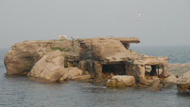
Fort Tyler is now referred to by sailors as the “ruins.” (Photo: Capt. Dave Brennan) |
The British used Orient as a staging area to launch attacks on many Connecticut coastal towns knowing many patriots from Long Island were hiding there. One of the first official battles of the American Revolution pitched a raiding party sent by General George Washington to where the Plum Island lighthouse now stands to intercept British cattle raiding parties; of course the colonial troops were routed and fled via Orient Point.
In fact, after Benedict Arnold escaped the West Point fiasco and a traitor’s hanging, he served as a British general operating out of Oysterponds (Orient). The Village Lane Tavern in Orient, the home of the founding Vail family, served as Benedict Arnold’s headquarters during the revolution.
Because of the notoriety of the Long Island Town of Oyster Bay during the Theodore Roosevelt Presidency, the residents of Oysterponds decided to change the town name to Orient, associating itself with the notoriety of Orient Point. Twenty-six years before the revolution Benjamin Franklin himself on a commission from the British governor of New York, who in the 1750’s was sometimes stationed in Riverhead, laid down stone “Postal Markers” from Riverhead to Orient Point. Many still stand today. There is no doubt Benjamin Franklin marveled at the view from Orient Point.
The first U.S. Federal Government, with George Washington as President was located downtown in New York City in Federal Hall for one year. That year, Thomas Jefferson and James Madison reportedly shared a coach that stopped in Mattituck at the Historic Mattituck Tavern on their way to view Orient Point. There are reports that George Washington himself visited Mattituck and stayed at the inn, back in 1751.
During the war of 1812 the British War Fleet returned to blockade the Long Island Sound and Gardiner’s Bay. However when they tried to come ashore at Sag Harbor, they were repelled on the docks by men led by a local American officer named Captain David P. Vail. However it was a menacing sight to see the mighty British War frigates off the Hampton’s shores as they lobbed cannon shells into Sag Harbor. Although Sag Harbor was shelled there are no reports of Orient being shelled. It may have been the shelling of Sag Harbor that led to the construction of Fort Tyler in 1898 at the western tip of Gardiner’s Island a point separating Gardiner’s Bay from Block Island Sound. The old fort is now referred to by sailors as the “ruins.” Closed after World War I in 1921, the fort became a target for live practice bombing runs during World War II. Live ordinance is reportedly still there, or so a “danger” sign warns.
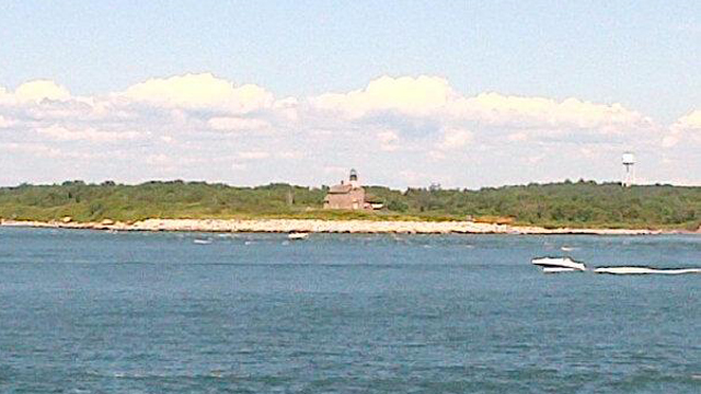
The Plum Island Lighthouse stands on land purchased by the United States government from Richard Jerome for $90 in 1826. The rough stoned lighthouse was completed in 1827. When I sail around the Plum Gut I love to look at it.
My boat goes in the water this week, hope to see you out on the Gardiner’s Bay!
 |
|
Purchased in 1826 for a mere $90, Plum Island (shown here) is a focal point for anyone on the ferry or boaters in Plum Gut. (Photo: T.J. Clemente) |


