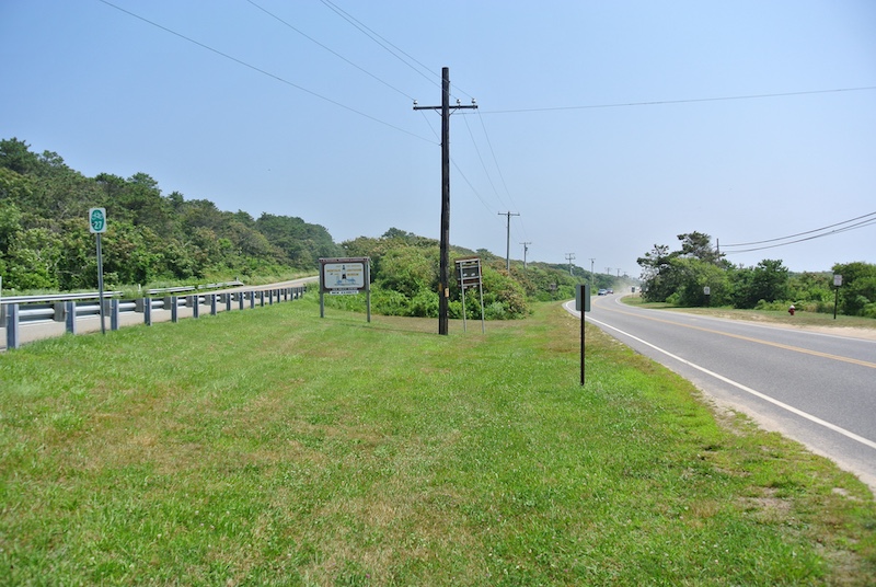
NY Route 27 East is the lifeline, pipeline, and only direct line to the Hamptons. It is the longest state route on Long Island, stretching 120.58 miles. It starts in Brooklyn, N.Y., and ends at the Montauk Lighthouse. Back in the 1960s, former Tonight Show host and frequent Sag Harbor visitor Johnny Carson used to jokingly call it “the world’s biggest parking lot.” Yet, to most Hampton visitors, residents, and workers, it is the road “most traveled.”
Old timers will tell you stories of its importance before there was a Long island Expressway. The actual signed Route 27 was born in 1920 and, at that time, only extended to Amagansett. Robert Moses, the great builder of N.Y. Highways had developed a plan to elevate Route 27 through Nassau County in order to service trucks but local store owners and businesses fought and killed the idea.
On the east end, it is called Montauk Highway, but like so many roads on the east end, it started out as an Indian trail. The Shinnecock Indians, as well as the Montauketts, took this route on the east end (Montauk) in order to trade wampum with other Indians located to the west. Some historians consider Adriaen Block, a Dutch Explorer, as the first known Western man to set foot in Montauk. In 1614, Block landed and interacted with the tribe at Montauk Point; Block named the Point Hoeck van de Visschers, or “Point of the Fishers.”
However, Lord David Lion Gardiner was the first settler to pass through Montauk while moving to Gardiner’s Island from Connecticut in 1639. As the settlement of what we now call Montauk progressed, the highway was laid out naturally as ranchers let their livestock graze on the Montauk peninsula in the 1700s. In 1792 George Washington authorized construction of the Montauk lighthouse and the project was completed in 1796. the first lighthouse in New York State. Originally Montauk Highway hugged the coast into the village and is now called Old Montauk Highway only after a more direct Route 27 was built to handle modern traffic.
However, over thirty years (1960-1990), the route between Lindenhurst and East Patchogue was gradually upgraded to a freeway-type road. The stretch from East Patchogue to Shinnecock Hills was built as a highway with exits from the beginning but was not updated again until the 1990s. Those with memories can remember, as did Johnny Carson, that as one approached Shinnecock Hills traveling east on NY 27, the road became three lanes only to suddenly become a single lane when it merged with County Road 39. That then formed a single lane in both directions, and that stretch was labeled “the Shinnecock Squeeze.” On weekends in the Summer, it might take over one hour to get from Hampton Bays to CR-39 with traffic stop-and-go. If a car overheated like it did back then or if there was a fender bender, then things would get uglier.
Using 2022 data from the National Highway Safety Traffic Administration, there were 934 highway fatalities on Long Island roads, with the majority of them (578) in Suffolk County. Although the highest number (62) deaths on Long Island occurred on Route 25, Route 27 was right behind with 62.
Finally, in 2006-7 more lanes were added at the “squeeze,” but anyone who was around then can remember the “cones” and massive bottlenecks that expansion created. As bad as traffic can become every workday morning and evening and on weekends like Sunday evenings heading west, nothing compares
to the pre-2006 Southampton Town Route 27 traffic jams at those same times. Oldtimers will testify that the flow has really improved, of course, to no relief to those who grapple with the traffic to get to and from work these days.
Trivia: The official distinction between “Montauk Highway” and Sunrise Highway is Sunrise Highway (NYS Route 27) – Connects Southampton/Brookhaven Town Line to County Road 39. Montauk Highway (NYS Route 27) – Connects North Road (County Road 39) to Southampton/East Hampton Town Line. Also, Amityville is the only town in Suffolk County where the NY 27 (Montauk Highway) is officially referred to as Merrick Road. Yet it is the same east-west road, no matter the signage and different speed limits.
First instituted in 1901, speed limits were assigned nationally to increase road safety. Thus, prevent accidents. Originally, individual states were responsible for determining their own speed limit laws. After oil shortages in the 1970s, Congress established a national maximum speed limit of 55 mph. The first-speed limit signs were posted at city and town limits. Early signs were not reflective. By the middle to late 20s, however, many cities required that speed limit signs be illuminated. The New York State legislature, in 1925, about the time of the official establishment of state highways, passed a law that “each city shall have placed conspicuously [signs on] each main highway, where the rate of speed changes [and signs shall be] adequately illuminated between sunset and sunrise.” That is the reason for the speed limit on Route 27 varying from 25mph in Bridgehampton by the school to 30mph traveling through Tuckahoe and 45-55mph in most other towns.


.
.
.
.
.
#shelterisland #treetops #awardwinningmodernhome #luxuryrealestate")
 is currently one of the hottest East End must-sees. Being able to watch the various whales, giant bluefin tuna, marlins, hammerhead sharks, and so many other fish feeding off Montauk in phenomenal drone-captured color footage is spellbinding.
Read the full article at Hamptons.com (Link in Bio)
.
.
.
.
#empireoftheatlantic #montauk #ocean #documentary")
.
🌼 Egg Hunt for Toddlers
📅 Saturday, April 4 | ⏰ 11:45AM–12:30PM
📍 Quogue Wildlife Refuge
Ages 2–4 with a special gift—sign up early!
🌷 Easter Egg Hunt in Amagansett
📅 Saturday, April 4 | ⏰ 12PM–1:30PM
📍 Amagansett Youth Park
Bring a basket and join the fun!
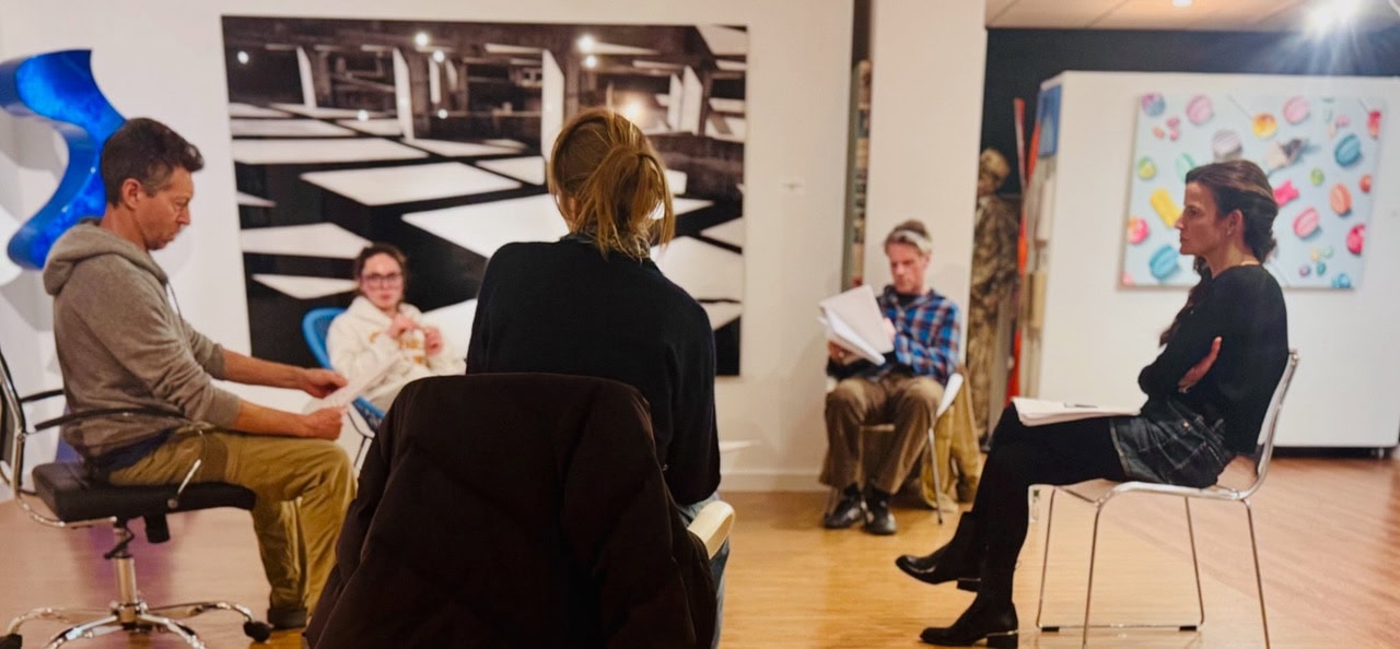
🖼️ A Thousand Words: Opening Reception
📅 Saturday, April 4 | ⏰ 6PM–7:30PM
📍 The Church, Sag Harbor
Preview this spring’s photography exhibition curated by Elisabeth Biondi.
🐰 Southampton Inn Easter Egg Hunt
📅 Sunday, April 5 | ⏰ 10AM–10:30AM
📍 Southampton Inn
Stay after for a classic Easter brunch buffet!
🍳 Easter at The Hampton Maid
📅 Sunday, April 5 | ⏰ 8AM–3PM
📍 Hampton Bays
Festive brunch, Easter Bunny visit & egg hunt for kids.
🥂 Easter Brunch at Nick & Toni’s
📅 Sunday, April 5 | ⏰ 11:30AM–2:30PM
📍 East Hampton
Celebrate with a special $95 prix-fixe brunch.
Check out more events at Hamptons.com (Link in bio)
#easter #hamptons #egghunt #art #sagharbor")

#hamptons #montauk #stpatricksday #hike #concert egghunt")

.
.
.
.
#hamptonsfilm #film #palmbeach #screening #colonyhotel")
